Key Takeaways (or TL;DR)
- Geolocation is a technical process of tracking the location of an object in real-time. In ride-hailing apps, this feature sets the base for pickup pin placement, ETA calculation, route suggestions, and fare estimation.
- Geolocation works through the combined synergy of three technologies: global positioning system (GPS), Wi-Fi positioning systems (WPS), and cellular networks.
- Through real-time location tracking, riders can not only track the live movement of the vehicle but also share it with their loved ones for trip monitoring.
- GPS acts as a central processing unit for taxi booking apps to navigate through unknown neighborhoods, optimize routes to reduce ETA, and introduce time-based fare calculation.
- Geolocation allows taxi apps to create geofences around demand zones, like airports and stations, to introduce surge pricing.
- During the time of crisis, geolocation aids passengers and drivers by helping the local support team constantly fetch the GPS coordinates of the vehicle in real-time.
- The sophisticated location intelligence helps riders experience a smooth riding experience, ensures drivers are fairly compensated, and aids fleet operators in optimizing the operation for maximum revenue.
- Leveraging Elluminati’s taxi booking app services can help businesses make the best use of the geolocation technology for more profit and customer satisfaction.
Geolocation in ride-hailing has become a non-negotiable expectation. Users perceive geolocation as a hallmark of reliability in a taxi booking app. Accurate geofencing helps in instant driver matching and accurate fare calculation. If real-time location tracking in ride-hailing is not accurate, it directly impacts customer retention.
However, most startups struggle to integrate geofencing into their ride-hailing app. It could be due to budget constraints, rushed launches, and underestimating real-world mapping challenges. This article explores all aspects of geofencing in ride-hailing apps. We will analyze its working principles, underlying technologies, role in passenger safety, and high-impact business use cases.
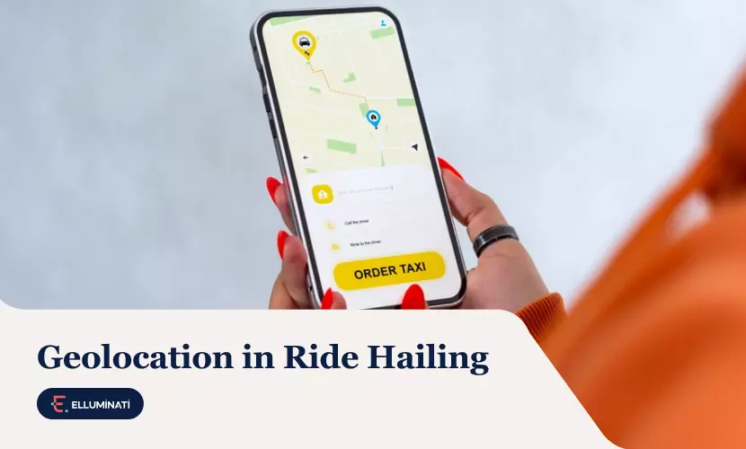
What Is Geolocation in Ride-Hailing Apps?
Geolocation in ride-hailing apps is the process of determining and tracking the real-time location of drivers and passengers to coordinate pickups, routes, and drop-offs. In a taxi booking app, accurate geolocation is necessary for pickup pin placement, ETA calculation, route suggestions, and fare estimation.
To pinpoint the exact location, the technology gathers clues from different sources, such as:
- GPS: identifying the signals from at least four different satellites within a few feet
- Wifi & Bluetooth: measuring location based on nearby Wi-Fi routers
- Cell towers: measuring signal strengths from several nearby towers to triangulate the object’s location
However, user permission is necessary to activate geolocation in ride hailing.
Technologies Used for Location Detection
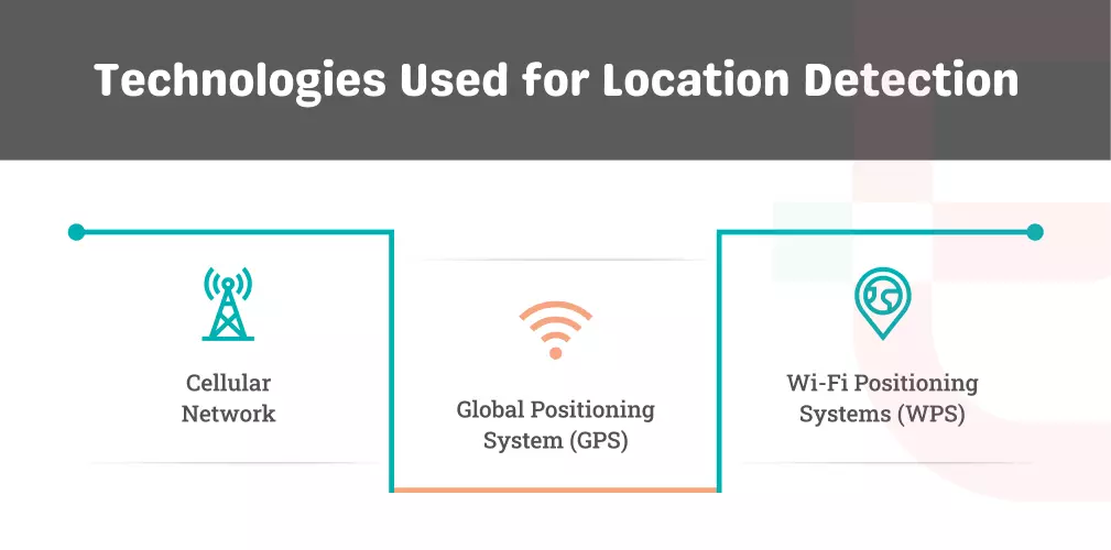
Real-time location tracking in ride hailing works in a symmetric coordination between three different technologies.
Global Positioning System (GPS)
There are about 30 GPS satellites orbiting Earth. Each one constantly beams out a signal about its proximity to your phone.
Since the signal travels at the speed of light, your phone calculates its distance from the satellite based on that time delay.
By calculating the distance from at least four satellites simultaneously, your phone finds the one point where all those “distance circles” overlap.
Wi-Fi Positioning Systems (WPS)
Every Wi-Fi router has a unique “fingerprint” called a Basic Service Set Identifier (BSSID). Even if a network is private and locked, the router constantly shouts its ID into the air so devices can find it.
Companies like Google and Apple have built massive databases (essentially a global phonebook) of where these specific Wi-Fi routers are located. This map is updated whenever someone with a GPS-enabled active walks past a router. Their phone tells the database: “Hey, I just saw Router ID 123 at these exact coordinates.”
When you are inside a mall or apartment:
- Your phone scans the area and sees five different Wi-Fi signals.
- It sends those IDs to the database.
- The system looks at the signal strength of each. If you have a strong signal from “Router A” and a weak one from “Router B,” it knows you are standing much closer to Router A.
By overlapping these signal circles, the phone can figure out which room you are in, even without a single GPS satellite in view.
When GPS is blocked, and Wi-Fi is spotty, your phone uses its own cellular connection.
Cellular Network
Each mobile cell tower has a unique ID and a fixed, known location on a map. Your phone measures signal strength from three or more towers. If Tower A is strong and Tower B is weak, the phone perceives it’s closer to A.
The network measures the Round Trip Time (RTT) for the signal from each tower (in milliseconds). As the speed of radio waves is already known, the distance from each tower is calculated down to a few hundred meters.
Nowadays, smart 5G towers use beamforming. Instead of scattering signals everywhere, they aim a narrow beam of data directly at your phone. The exact angle and distance of that beam help the network pinpoint your location with ease.
How Real-Time Location Tracking in Ride-Hailing Works
Geolocation helps ride-hailing businesses track a booking from start to end. Here is how it works:
Live Driver Tracking
When you see that little car icon moving on your taxi booking app, you see a stream of real-time data packets.
Every few seconds, the driver’s app sends a signal to the company’s server. It contains the latest GPS coordinates, speed of driving, and heading (direction). The server instantly pushes it to the app.
The app uses a virtual invisible fence around your pickup spot, also known as a geofence. When the driver’s GPS enters that fence, the app automatically pings you.
If a driver takes a detour due to a sudden accident, you can see it on the map. This helps in reducing support tickets for ride-hailing companies, as every support call costs money.
Trip Tracking During the Ride
During the transit, the app records a trail of GPS coordinates. This serves for route audit and actual distance calculation.
If the driver takes an unnecessary detour, the system flags it. The app further counts the space between recorded GPS coordinates to verify distance for billing purposes.
When the driver makes dynamic route adjustments under certain situations, the geolocation data detects this change in real-time for verification. It helps the company decide if they need to adjust the driver’s pay for a trip that took longer due to on-road challenges.
If the GPS coordinates stop moving for too long without a notable reason, the system can automatically flag the trip for the safety team to monitor.
Location Sharing and Trip Monitoring
Geolocation can convert your private GPS data into a temporary, shareable link to keep your loved ones in the loop. The app generates a unique, encrypted URL that allows your friends to temporarily access your live data stream. As soon as the trip ends, the link expires, and your location data becomes private again.
Using Geofencing, the app can automatically text your contact the moment you arrive safely. If you use the in-app emergency button (SoS), the app sends your live GPS coordinates directly to local dispatchers.
This virtual vigilance encourages professional behavior from the driver and provides a layer of security for the passenger.
Build a Better Taxi App with Elluminati’s Real-Time Tracking Using Advanced Geolocation Technology
The Role of GPS Tracking in Taxi Booking Apps for Navigation and Fare Calculation
For taxi apps, GPS acts as a CPU to balance speed, cost, and efficiency. Here is how it handles the two biggest challenges:
Navigation and Route Optimization
To thrive in this on-demand taxi booking market, the ride should be completed through the shortest route possible. Sometimes, the shortest route can be the slowest due to multiple traffic stops. GPS tracking helps taxi apps to measure the path with the lowest traffic density to complete the ride faster.
If ten drivers suddenly slow down on the main street, the app instantly reroutes the driver to save time. To reduce wrong-turn anxiety, it further provides visual and audio cues. The driver can smoothly navigate through an unknown neighborhood without missing an exit.
Distance and Time-Based Fare Calculation
Ride-hailing apps use GPS Breadcrumbs. Every few seconds, the app calculates the distance between two GPS coordinates and keeps repeating the same for the entire ride. By adding all the parts, the app calculates the total distance travelled. To avoid GPS glitches, like dots jumping across buildings, all coordinates are snapped to the nearest road on the map.
In big cities, users pay for both distance and time. The GPS constantly detects if the car is moving slower than a certain threshold (e.g., 15 km/hr). If it is the case due to heavy traffic, the app switches from a per-mile to a per-minute rate. This ensures the driver is fairly compensated for sitting in gridlock.
Geofencing in Ride-Hailing Apps
Geofencing is about creating a virtual perimeter around a physical object. The virtual perimeter is made of GPS coordinates and codes. When a device (e.g., a phone) crosses that invisible line, it triggers a pre-programmed action.
Let’s understand how geofencing helps ride-hailing apps in different aspects.
Airport and Restricted Zone Management
The app creates a geofence around a specific “Staging Lot” located away from the terminals. A driver only enters the “dispatch queue” once their GPS enters that specific geofence. If they leave the lot to get coffee, the geofence detects the exit and automatically removes them from the line.
Most airports have designated taxi pickup signs at specific pillars. If you try to request a ride while standing at the arrivals curb, the app may detect you’re out of geofencing and block the ride request until you reach the pickup zone.
Geofences protect riders from entering restricted zones, like pedestrian-only plazas, government buildings, or high-security areas. If a passenger requests pickup inside a restricted zone, the geofence will automatically shift the pin to the nearest public access point.
Surge Pricing and Demand Zones
Geofencing allows the app to pinpoint high-traffic areas in a city in real-time and change the rules for dynamic pricing.
Taxi booking apps use polygon geofencing to create surge zones, where demand is spiking. When the rider-to-driver ratio crosses a certain threshold, the geofence activates surge pricing only for people inside that boundary.
There can be three types of geofences.
| Type of zone | Role of geofencing |
| Fixed zones | Areas, like airports or train stations, have a base surge because demand is high 24/7. |
| Event zones | A temporary geofence is drawn around the location (e.g., a stadium) just for a few hours after the event ends. |
| Predictive zones | The app pre-emptively creates a demand zone around the location (e.g., a nightlife district on Friday nights) before the rush even starts. |
Driver Incentives and Smart Zones
Geofences also incentivize drivers with an additional bonus to be in the surge zone. They get the extra “surge pay” if their GPS shows they have actually crossed the line into the high-demand geofenced zone.
To prevent drivers from just driving in and out for incentives, the geofence requires them to accept the next ride request within that boundary. If the pickup happened one inch outside the geofence, the system automatically knows.
Smart cities use geofencing to send a signal to the driver’s app when they enter a school zone or a high-pedestrian area. The app may provide a loud audio warning or even “throttle” the app’s dispatching.
Role of Geolocation in Ride-Hailing Safety
During the time of a crisis, every second matters. Let’s see how geolocation aids stressed passengers and drivers during times of crisis or emergencies.
SOS and Emergency Response
Ride-hailing apps feature a red SOS button. When it is pressed, the app sends the current coordinates, vehicle information, and the driver’s ID to local emergency dispatchers (like 911).
The exact latitude and longitude allow policemen or an ambulance to find you. The app can even livestream the vehicle’s movement to a safety response team. This is vital for the response team to stop the car, even if the driver diverts the vehicle in the wrong direction.
Route Deviation Alerts
When you start a trip, the app draws a geofence corridor around the expected route. If the vehicle’s GPS coordinates move outside that geofence for more than a set time or distance, the system flags the trip.
The app cross-references the current GPS data with live traffic data. If it’s a detour to avoid bad traffic, the system considers it a safe deviation. Otherwise, unexplained detours are recognized as a high-risk anomaly.
The system immediately sends push notifications to both the rider and the driver asking if everything is all right. In many cases, a human safety agent at the company’s HQ is alerted to look at the live map.
Incident Tracking and Support
In case of any major accident or dispute, geolocation turns the entire GPS breadcrumb trail into a digital eyewitness.
For example, if riders claim they were overcharged, support agents can check the GPS trail to understand the reason. If it is an unnecessary detour, the team can immediately issue a refund.
If passengers leave their phone in the car, geolocation allows the support team to easily locate the phone’s GPS coordinates and connect with the driver to coordinate the return process.
Strengthen Platform Trust with Geofencing. Secure Every Trip at Scale with Real-time Geolocation Monitoring
Use Cases of Geolocation for Ride-Hailing Businesses
Let’s take a look at some use cases to understand how geolocation optimizes user experience for riders, maximizes earning potential for drivers, and improves efficiency for fleet operators.
Riders
Geolocation turns a simple ride into a personalized service for riders in many different ways.
Faster Pickups
- Drivers save time by receiving a turn-by-turn navigation guide directly to the passenger’s location.
- Geolocation reduces idle-time by alerting the rider to reach the curb by the moment the driver’s GPS enters the pickup zone.
Accurate ETAs
- Based on GPS data of other vehicles, the app can divert drivers away from sudden accidents or heavy congestion.
- Accurate ETAs reduce rider frustration, resulting in fewer angry calls and ride cancellations.
Transparent Pricing
- Drivers get paid for verified mileage tracked through the exact breadcrumb trail of the vehicle.
- As the driver crosses geofences for bridges, tunnels, or airports, the app automatically adds the correct tolls to the fare.
Drivers
Geofencing improves the operational efficiency of drivers by facilitating for:
Reduced Idle Time
- Drivers receive accurate demand forecasting around probable neighborhoods based on historical GPS ping data before the rush starts.
- Drivers can set a “geographical filter,” so the app only assigns trips that end near their current location or on their way home.
Smarter Trip Allocation
- If a driver is on a trip and is 2 minutes away from the destination, the app uses GPS trajectory to assign the next pickup nearby.
- Based on directional matching, the app can assign the trip to the driver moving towards the customer rather than otherwise to reduce the ETA.
Operators
Geolocation allows fleet operators to oversee thousands of trips simultaneously and achieve the following advantages.
Operational Efficiency
- By matching the closest available driver to a rider, operators save fuel and reduce dead mileage.
- Operators use GPS to track idle drivers and use incentives to move them to demand zones for better fleet utilization.
Higher Platform Revenue
- Operators can identify demand hotspots and apply fare multipliers to increase the total booking value and platform commission.
- Operators can set higher base rates around airports, offices, or restricted service areas to maximize returns on every trip.
Better Decision-Making
- Operators can analyze heatmaps to identify underserved neighborhoods and focus their driver recruitment efforts there.
- By analyzing historical GPS data for slow routes, operators can improve ETA algorithms or work with city planners to suggest better pickup/drop-off infrastructure.
How Elluminati Can Help You Leverage Geolocation in Ride Hailing Apps
Leveraging the strategic advantages of geolocation in ride hailing apps is one of the basic technical requirements you can expect in 2026. As every second of wait time matters, having sophisticated location intelligence can separate your business from struggling startups.
However, there should be technical and operational clarity. Entrepreneurs must know how to scale from A-GPS and real-time tracking to intelligent geofencing without burning resources more than required.
This is where Elluminati can offer you the required competitive advantage. With over 14 years of excellence in developing scalable, feature-rich taxi applications, we provide the technical expertise to integrate world-class geolocation features from day one. Whether you want to integrate dynamic demand heatmaps or automated safety alerts into the app, our taxi booking app development services cover them all.
FAQ
In ride-hailing apps, geolocation is the “digital handshake” between a rider and a driver. It identifies the exact latitude and longitude of both parties by using a combination of satellites, cell towers, and Wi-Fi signals.
No, ride-hailing apps depend on cellular towers and Wi-Fi routers to overcome GPS limitations. GPS signals can not penetrate dense construction well. So, ride-hailing apps connect to nearby Wi-Fi routers and cell signals to ensure the location accuracy of the driver or the passenger.
Geolocation directly impacts ETA accuracy, battery life, and matching efficiency of ride-hailing applications. A constant stream of accurate GPS data allows the app to calculate an accurate ETA. It also enables the app to find the closest available driver to reduce user frustration. However, the app must balance frequent updates with battery preservation.
Geolocation creates geofences around specific neighborhoods. When the app detects the rider-to-driver ratio is higher than a set threshold within the geofence, it triggers surge pricing. Drivers are incentivized to head into the demand zone, and non-urgent riders are discouraged from booking until the crowd clears.
Yes, absolutely. Geolocation is an essential core feature of any white-label ride-hailing software. The feature comes integrated with mapping APIs (like Google Maps or Mapbox). They include three interacting components: the rider app, the driver app, and the admin dashboard.